IMPORTANT INFORMATION
The land on which Ma Peggy is located is private and this includes the route to get there. This must be respected. Please do not tackle the climb before gaining authorisation from the land owners. Chris & Louise can help with this and will guide any guests who stay at The Lookout - all part of the service!
WHAT DO MOST PEOPLE EXPECT FROM ONE OF THE CARIBBEAN’S BEST SHORT HIKES?
For a start, it needs to be a little challenging (without being intimidating) and accessible to those who are at least of average mobility & fitness. It’s also nice if it feels “off the beaten track” and a real bonus if you don’t bump into another sole for the entire ramble. It’s important for the sweaty brow & sore legs to be rewarded with a jaw-dropping view. After all, you need to take some snaps to make all your friends & family envious of your tropical location & momentous achievement. And finally, if you can get all this done in 2-3 hours and be sipping a beastly cold beer at the beach to end it all, then what’s not to love?!
The hike to “Ma Peggy” ticks all these boxes and is, quite rightly, a must-do activity on any trip to Bequia paradise. In this blog, we’re going to describe the route and we include some maps and pics so you can visualise the experience before you bite the bullet to tackle it for yourself.
WHY IS THE HIKE CALLED “MA PEGGY”?
Bequia is well known for its rumours, some of which are actually true (at least partly) and the rumour surrounding the name of this hike has some merit we are told. Peggy Kydd apparently had incredible eyesight and used to regularly take the hike to sit up on the rocks at the summit. She would look out to sea & point out where the shoals of fish were to the fisher folk in their boats down below. Real teamwork!
WHAT YOU WILL NEED & WHEN TO GO
Camera, sunscreen, hat, water, snacks, and maybe a walking stick too (helpful, but not entirely necessary). In terms of footwear, you don’t need hiking boots as trainers/sneakers with a half decent grip will suffice. Some folks have been up & down in flip-flops, but this really isn’t recommended!
We’d advise to start the hike at around 8am (or even earlier) to avoid the heat of the sun. However, it’s also nice (and maybe preferable) to set off at around 2pm to catch the late afternoon sun that will light up the bay in a spectacular way once you reach the summit. This timing will also mean you will be in & around the beach bar for sunset and a cool off in the Caribbean Sea.
Also, please familarise yourself with the Brazil plant which you will find around Bequia and almost certainly on the route up to Ma Peggy.
Brazil is a member of the Anancardiaceae family, to which Poison Ivy also belongs, and the effects of contact are similar.
All of these toxic plants produce an an allergenic oil (urushiol) which causes severe itching followed by blistering two or three days after even the slightest contact with leaves or bark in which the sap is running. Wash skin with cold water if you think you have had contact. Also wash the clothing you have been wearing.

THE BRAZIL PLANT
STARTING THE MA PEGGY LOOP
There are a few different versions of this hike, with various versions of the start point and route up & down. As our rental villa & apartments, named “The Lookout”, are located in Lower Bay, we will describe a route that starts & finishes there, with a well-deserved beverage and swim stop at one of beach bars at Lower Bay beach. This looped route takes in the areas of Friendship & La Pompe, then the walking on concrete ends as you get off-road and ascend across the ridge and up to the peak. After the obligatory Instagram poses, a snack, a drink, and a rest in the cooling mountain-top breeze, the descent then involves a tricky, but shaded scramble down a dry* stream bed into Lower Bay village. (*Note: We wouldn’t encourage anyone to take on this hike if it’s been raining heavily for a few days as the conditions will be slippery and the “dry” stream bed may actually have become a waterfall!)
Here’s a map and photo highlighting the start point at the bottom of the driveway leading up to “The Lookout”. The first 20 minutes or so will take you along the main road that runs through Bequia, so be especially vigilant for the speedy minivan drivers on some of the blind bends.
Start your engines, let’s go!
THE START POINT AT "THE LOOKOUT"
FRIENDSHIP & LA POMPE
From the start point head away from Lower Bay up to the junction with Bequia’s main highway. Turn sharp right and climb the short hill to where Chrissy’s Bar (or the Heineken Bar) is located. This is a part of the island that is less than a mile wide, so you will see the Atlantic Ocean ahead and The Caribbean Sea behind. Take in those welcome breezes. You can see the Friendship bus stop which also serves as a place for locals to rest, chat & laugh. Well, this area is called “Friendship” after all.
The road splits at this bus stop, so take the right fork and start your journey on the downhill & flat towards “La Pompe”. By the way, the island you can see on the horizon is Mustique. A private island about 5 miles across the water from Bequia, where the royal family and celebrities go on vacation. Mustique home-owners Jagger & Bowie once famously ate pizza at Mac’s on the Belmont Walkway. Tony Gibbons beach had a name change when Princess Margaret popped over from Mustique and decided to swim just off that particular stretch of sand in the 1960’s. You can visit the island on day trip by taking one of the organised trips on boats such as “Friendship Rose” or “Gusto”. Highly recommended. In summary, it’s a bit like Bequia but with pristine roads, golf carts, and neatly pruned hedges.
TAKING THE RIGHT FORK AT FRIENDSHIP TOWARDS LA POMPE
Concentrating back on the hike, the road winds along with Friendship Bay to your left. This is the home of the only hotel of note on the island – the Bequia Beach Hotel boasting 56 rooms, two restaurants, and two pools. The Swedish owner, Bengt, also purchased Jack’s Beach Bar at the end of Princess Margaret Beach several years ago.
The road passes landmarks such as Diamond restaurant and before you know it, you’re at the end of Friendship Bay and on your way into La Pompe. You will pass a painted sign on your left at the entrance to Bequia Beachfront Villas then the road winds to the right with views across to the uninhabited islands of Petit Nevis & the Isle a Quatre. These are both for sale at US$25M and US$54M respectively if you fancy purchasing your very own private island.
At your next left-hand 90 degree bend, it’s time to get off-road and start the climb to Ma Peggy. This is a bit of a cheat cut-through as it saves further road walking to a start point that most folks use which is several hundred metres further on. However, although it does cut the corner, you will soon realise that this part of the walk is steep & tough and therefore it isn’t cheating really.
Before starting the climb up the steep driveway, you can rest awhile and gaze up at Alize. This white property at the top of the hill once featured on the UK TV programme, “A Place in the Sun”. The house-hunters didn’t actually buy it (or any other property for that matter) but you may wish to google the St. Vincent & the Grenadines episode to watch later with your feet up.
HEAD UP THE STEEP DRIVEWAY TO ALIZE
THE START OF THE CLIMB
Once you have climbed the driveway to the property Alize, continue to make your way up the grassy bank. Aim for the goats grazing at the top. When you get there, take a break and admire the views (which are only going to get better as you progress). You’re in the right place if you find a rusty old dump truck that has long since changed its purpose to become a plant pot. From here, the basic guidelines are to follow the ridge to your right (as you look south to the islands) up to the summit of Ma Peggy. Encouragingly, the short, sharp & steep hill is now behind you and it’s more of a gradual, but not insignificant, climb to glory from here.
Keeping the island of Petit Nevis to your left and Friendship Bay to your right, head off and find the remains of a wooden fence and you will see the start of some kind of trail. You will know pretty quickly if you are on the right track as you will come across a lovely renovation project for someone with ambition & deep pockets. With a big dollop of TLC, this wooden shack could make a wonderful home or even a bar/restaurant with a view. Continue to the right of this building as you progress up the hill.
TAKE A REST WITH THE GOATS, BEFORE HEADING ON THE TRAIL PAST THE SHACK
The steady incline continues along a path that is sometimes quite slippery, with dry volcanic stone underfoot so take care. Soon you will reach a grassy meadow and you can see a green hill in front of you which is the basic direction that you need to head towards. At one point you will come to a fork in the path, so stay left. After a little while you will begin to head back out of the clearing and into the trees & shade. The path steepens towards the end of this section and you will feel like you need & deserve another break – which is exactly what is on the agenda!
WORK YOUR WAY UP THE RIDGE, THROUGH THE MEADOW, & EVENTUALLY TO A STEEP, ROCKY CLIMB TO A T-JUNCTION (GO LEFT HERE)
A REST STOP WITH A VIEW TO THE AIRPORT & MOONHOLE
At the top of this thigh-burning clamber, you arrive at a T-junction. The route to Ma Peggy is to the right, but let’s find a spot for another break with a view shall we. Go left and keep going in the direction of the off-shore islands just for a few paces. A wonderful sneak peak of Bequia’s airport will start to come into view and there are a few roughly constructed benches nestled in to the bushes where you can rest up & take photos.
This is the tiny J.F. Mitchell airport, named after the former Prime Minister of St. Vincent & the Grenadines – Sir James or “Son” Mitchell. He was PM between 1984 and 2000, after which he was a regular fixture at his bar/restaurant “Fangipani” on the Belmont Walkway. He sadly passed away, aged 90, in November 2021.
From this location, you can also see the thin peninsula known as Moonhole and the Liming Hotel, with its straw-roofed restaurant & bar jutting out into the water before the sands of Adam’s Bay. The latter was only recently built and is a nice place to have lunch and hang by the infinity pool, sipping cocktails. Moonhole has a far more interesting history. Tom and Gladdie Johnston formed the Moonhole company in 1964 and constructed Flintstone-like stone houses on the 30-acre site. This private reserve cannot be accessed by the public these days and is best viewed from the sea by boat.
TAKE A REST AND ADMIRE THE VIEWS OF THE GRENADINE ISLANDS & THE AIRPORT
You have now “broken the back” of the climb and it’s about another 15-20 minutes from here to Peggy’s Rock. Look out for wildlife in this shaded section. The Bequia land turtle and hermit crabs are the most likely creatures that you may encounter.
Heading back along the path, the junction where you have just climbed is to your right so continue straight ahead. Pretty soon you will periodically encounter rocks with painted instructions that have faded over time. Look out for the first sign to Lower Bay on your right as this is the way back home. There are several path options to Lower Bay, so remember on your way back down to take this one and not the first turn-offs you encounter after leaving the summit.
The pleasant, shaded path begins to change as you approach the final stages. You will need to clamber up, over & around some larger rocks that lie in your way. After 5 minutes or so, you will realise that you have reached the end of the line as some large, imposing rocks lay ahead. Take a deep breath and carefully make the final ascent.
THE SHADED PATH CONTINUES PAST ROCK SIGNS AND THEN BECOMES A CLAMBER TO THE PEAK
REST & REWARD AT THE SUMMIT
The final hoorah involves a clamber up the large rocks to be greeted by a awesome 360-degree view. It feels like you are on top of the world here and hard to believe you are only up above sea-level to an elevation around 900 feet (275 metres). As you will notice, there isn’t a great deal of space at the top of Peggy’s Rock, so take care when posing for photographs, as a trip or a gust of wind could result in a very long bungee jump without a cord!
Now that was worth all the sweat and tired legs wasn’t it!? Looking south on a clear day it’s possible to see as far as Grenada which lies nearly 70 miles away. Between Bequia and there lie many Grenadine islands, strung out like a kite’s tail to the horizon. The most immediate islands you can see are Petit Nevis and the Isle A Quatre and south beyond these you should easily be able to make out Canouan and then (if it’s clear) Union Island, Petit St. Vincent, Carriacou & Grenada, to name but a few. There are 32 islands & cays that make up the country of St. Vincent & the Grenadines. Now you have a more elevated view of the airport and Moonhole and, if you’ve timed it right, you may be able to see the tiny SVG air planes landing & taking off again. Give them a wave!
ON TOP OF THE WORLD!
The view north provides the mantle-piece photograph or updated cover photo for Facebook. The view of Bequia and beyond to St. Vincent is truly spectacular. Taking an afternoon walk will mean that the bay and beaches below are lit up and bathed in sunlight. Guide your eyes from Lower Bay to the headland where your start point at “The Lookout” lies. You can quite clearly see the yellow property glistening on the hill. Looking further beyond you will see Princess Margaret beach, the town of Port Elizabeth and also the areas of Hamilton, Level, & Spring.
SOAK UP THE VIEWS AND YOU CAN PICK OUT YOUR START POINT AT THE LOOKOUT WAY DOWN BELOW
THE DESCENT TO LOWER BAY & BACK TO CIVILISATION
Once refreshed, it’s time to head back down. This descent should be faster than the climb, but take care as tired legs & minds can often lead to trips & falls. Keep your concentration until you’re back on the flat land of Lower Bay and you’ll be fine.
The initial part of the route back is simply the reverse of the way you came. Remember to NOT take the first turn off options and opt for the final one to your left. You will see the rock and an arrow pointing the way to Lower Bay.
After a few minutes there is one split in the path, so stay left. A further few minutes down the path and the scramble to Lower Bay begins in earnest. You will see ahead that you are now on an old stream bed that is cut all the way down the hillside. There is no dignified way to tackle this kind of terrain. At times you will simply have to get on your bum and shuffle down certain sections, watching your footing on loose rocks as you do so. These hard yards allow you to drop elevation and get you closer to that cold beer more quickly. In reality, the worst of it only last for around 15 minutes.
IT'S A SCRAMBLE DOWN THE DRY STREAM BED - TAKE YOUR TIME
Eventually you will start to glimpse the sea of Admiralty Bay and its anchored boats ahead. The next bit is a little tricky to describe. Keep following the stream bed but also start to look out for signs of a concrete road which will be running parallel to the streambed, about 5-10 metres to your right. You should find an opportunity to exit and traverse the small distance from forest to terra firma. You’re back in civilisation!
A GLIMPSE OF ADMIRALTY BAY, THEN SIDETRACK FROM THE STREAMBED TO THE ROAD DOWN TO LOWER BAY VILLAGE
BEER O’CLOCK
Follow the steep concrete road down through the back streets of Lower Bay village. You eventually will come to Petra’s restaurant on your left. Petra has the biggest smile in Lower Bay and cooks up great value home-cooked grub. Everything from breakfast omelettes to West Indian curry to freshly grilled lobster. She also bakes everyday and provides the bread that form part of the generous & complimentary welcome pack we give to our guests at The Lookout.
Turn right at Petras and you are on the Lower Bay beach road. Now it’s time to pick your place for a well-earned & beastly cold Hairoun beer! De Reef or Keegan’s are both very pleasant spots right on the beach, so you can dash into the warm Caribbean Sea to cool off too.
DE REEF BEACH BAR & RESTAURANT
Congratulations you made it. We hope you enjoyed one of the nicest short hikes in the Caribbean, if not the world. More walking blogs will be made available on our website. If you’re planning a trip to this wonderful island, you may wish to consider staying at our boutique apartments named "The Lookout". We always go above & beyond for our guests and that includes taking them on guided hikes like this one – all part of the service!
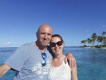
CHRIS & LOUISE - THE OWNERS OF THE LOOKOUT BOUTIQUE VILLA & APARTMENTS IN LOWER BAY


.jpg)


.jpg)